Participate to Build the Administrative Record
Sonoma Valley, CA Land Use Challenge
Wildfire evacuation in Sonoma is challenged by geography and demographics.
This narrow tourist-centered valley is bordered to the east and west by Sonoma Mountain and the Mayacamas range.
Evacuation of the area at the current levels of development involves more than 44,000 vehicles and 50,000 people - including residents, workers and visitors.
Given public officials continue to propose large-scale developments in this fire-prone area, and have not completed a cumulative impact analysis, local groups, donors and affiliates developed grass-roots community support to fund both legal and technical studies to protect public safety during a wildfire.
Sonoma Valley communities followed the requirements of the California Environmental Quality Act (CEQA) and built a strong Administrative Record.
LEARN MORE: Resources - California Environmental Quality Act.
Fully participated in a 3-year county Specific Plan development process (entered tech studies, including transportation infrastructure inadequacy analyses: Primer Transportation Infrastructure’s Role in Evacuations
Built a strong administrative record; thus, the community was able to Challenge the Project Approval and Win in Court: The project’s Specific Plan Approval and EIR were set aside by the Judge given inadequate public safety analyses.
Then, funded an Emergency Traffic Evacuation (ETE) Study - to submit into the administrative record for the new even larger project proposal. The ETE study includes cumulative impact analyses for current traffic plus the Eldridge and/or Hanna and/or The Springs proposed large scale developments.
Community WINS in Court: Judge agrees EIR Evacuation and other Public Safety Analyses were Incomplete
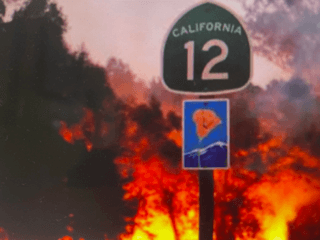
Given new developments and existing communities rely on the same constrained two-lane evacuation routes - CA Route 12 and Arnold Drive - the main North -South routes through this high wildfire hazard severity zone. Even traffic accessing the narrow, windy East-West routes that travel over the mountain ranges must rely on CA Route 12 and Arnold Drive to access their evacuation road.
From 2021 to 2023, SAFRR joined with local community groups to provide extensive input into the County’s Sonoma Developmental Center (SDC) Specific Plan and produced technical reports defining the deficiencies in its Environmental Impact Report (EIR). However, the Final EIR did not adequately address the transportation infrastructure's limited capacity, present realistic evacuation times to locations outside the area of risk, and other public safety concerns. The County did not study cumulative impacts, even though there are three large-scale projects in the planning phase.
In 2023, community groups challenged the County’s land use decision in Court, and the Judge found in favor of community plaintiffs. Judge Bradford DeMeo, found in favor of plaintiffs, who sued the County given the inadequate EIR for the proposed Sonoma Developmental Center project:
The judge ruled, in the context of concerns about Evacuation and other public safety factors, that:
“...the purported mitigation measures in the Plan, its goals and policies, are on the whole factually toothless, vague, and limited to hopeful intentions... with no definition of what any of this means, no performance standards, and no clear criteria.”
Despite the community’s win in court, in 2024 Sonoma County officials continued to move forward plans for several large-scale developments in the study area – Sonoma Developmental Center/ now a larger, more-impactful proposal known as Eldridge LLC, Hanna Center and The Springs.
Thus, the community mobilized again for a potential future lawsuit by proactively contracting for and funding an evacuation (ETE) and cumulative impact study known as the “Sonoma Area Fire Evacuation” (SAFE) study.

Sonoma Area Fire Evacuation: SAFE
FINDINGS: The SAFE technical analyses indicate that, at current traffic levels, the evacuation routes will experience GRIDLOCK.
The residents self-funded a professional engineering firm contract to develop a data-based study of evacuation scenarios.
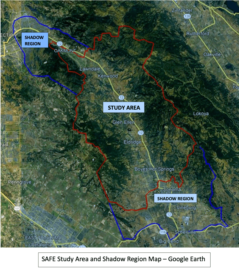
The Sonoma Area Fire Evacuation Study (SAFE Study) and its Evacuation Time Estimate (ETE) methodology uses the distribution and density of people, vehicles, and facilities as input to quantify travel times under various likely scenarios: for fire direction and speed – advanced warning and time to mobilize; and traffic levels: current levels of traffic only– and several future traffic scenarios. The SAFE study ran a cumulative impact study, modeling existing traffic plus additional traffic from up to the three proposed new developments.
The February, 2025 SAFE Report Press Release summarizes the SAFE Evacuation Study's key findings for current traffic levels as well as projected increased traffic from planned new developments.
The findings validate real-life evacuation experience during the 2020 Glass Fire. The study, using standard traffic engineering methodology, concluded that the available roadway supply is “Not Sufficient” to service the evacuation demand, even at current traffic levels - even without the additional demand from proposed new developments.
The study also estimates that one hour after an evacuation is ordered, the traffic (normally traveling 45 mph on Arnold Drive and CA Route 12 between Kenwood and City of Sonoma limits) will slow to one to two (1-2) mph for another 2-3 hours, seldom approaching five (5) mph.
Background: The community contracted for the Emergency Traffic Evacuation study to prepare for the next phase of land use decisions. The County is reviewing a new, even more Impactful, proposed Project: In December 2024, the County set aside the Specific Plan and its EIR and is supporting the State’s chosen developer in its preparation of a new plan for the Eldridge LLC site. The County “missed the deadline” for filing its Housing Element, which allowed the developer to invoke “The Builders’ Remedy” loophole, proposing even more housing at the site. The Eldridge Renewal LLC October 8, 2024, proposal includes 990 residential units, a 150-room hotel with parking structures and associated amenities, and 130,000 square feet of commercial development. And, in 2025, the developer proposed additional changes, including destroying the historic buildings.
This new project will require an adequate EIR, informed by technical studies. Thus, the Sonoma Area Fire Evacuation (SAFE) Study can be used as technical input to the new EIR. The report is at this link: PDF Report released in February, 2025.
LEARN MORE: