PRIMER: Transportation Infrastructure’s Role in Evacuation
From 2021 to 2023, SAFRR provided input on Sonoma Valley’s proposed new development, including technical reports and analyses questioning the findings of the Sonoma Developmental Center (SDC) Specific Plan’s traffic analyses and the Final Environmental Impact Report’s (EIR) inadequate evacuation analysis.
Evacuation Standards: Firefighters must evacuate an area before they can begin fighting a rapidly growing fire; thus, overall protection of life and property is reliant on timely evacuations. Evacuations are also dependent on the number of zones needing to be evacuated and whether emergency vehicles can enter the area at the same time that residents, workers and tourists are evacuating. Evacuation analyses rely on transportation system data – road geometry, congestion levels, trips generated by various types of land uses, and both the number as well as the type of vehicles evacuating (i.e., autos vs. vehicles pulling horse trailers).
Safe Evacuation relies on time: both lead time – based on the speed of the fire and amount of advanced evacuation warning - and travel time based on traffic congestion and/or accidents along the evacuation route. Evacuation lead time needs to be greater than the travel time for vehicles to “clear the fire risk area.”
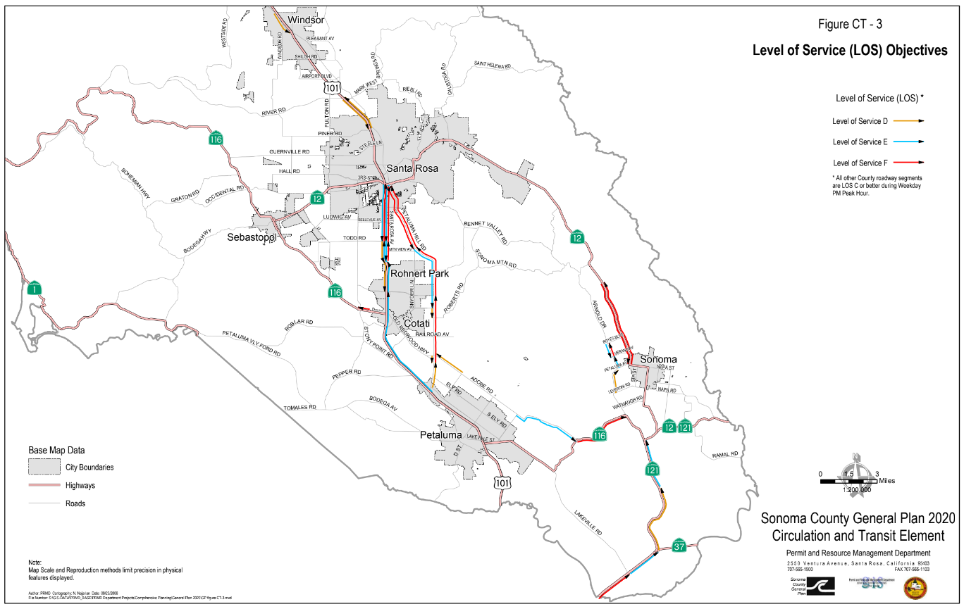
Key: The Red and Blue lines on Figure CT-3, indicate sections of roadways the County exempted from its “congestion significance” standard – a standard that triggers upgrade requirements, so roadways operate at Level of Service (LOS) D for existing roads LOS C for new roads.
Sonoma County, CA: As input to the 2023 lawsuit challenging the County’s decision to approve a major new development, SAFRR defined the inadequacies of the Sonoma Valley road system to accommodate evacuation, noting that safe evacuation is compromised even without the proposed new development.
SAFRR entered technical engineering reports into the record, including a Level of Service (LOS) road capacity study omitted from the Final Environmental Impact Report (EIR), and questioned the County’s decision to retain exemptions for key evacuation routes from “congestion significance' criteria codified in the General Plan.
W-Trans report “July 2022 Focused Traffic Operation Analysis” was omitted from the Final EIR even though it provided LOS data and analysis of current and future traffic congestion on both segments of key evacuation roads and at intersections.
Level of service (LOS) is a term used to describe the operating conditions of a roadway based on factors such as speed, travel time, maneuverability, delay, and safety. The drivers’ experience on a two-lane highway or arterial road at Level of Service (LOS) D, E or F is as follows:
LOS D is the warning sign: Traffic is approaching unstable operations – there are Stop and Go surges - and even small increases in volume produce substantial decreases in speed and increased travel delay,
LOS E: Roadway is operating at capacity with low speeds and increased time delays; and
LOS F: Traffic progresses at low speeds with backups at intersections – high travel time delay - essentially gridlock.
Conditions have changed: The County’s exemptions to criteria requiring upgrades to roadways and intersections were authorized around 2008 when Sonoma Valley roads were primarily rural resident and tourist routes. Now, these roads are major evacuation routes.
Now, evacuation from the valley requires travel on highly congested CA Route 12 or Arnold Drive. Even access to the east-west evacuation routes – primarily constrained roads crossing the mountains - require travel along these highly congested north-south routes.
Experience during the 2020 Glass Fire evacuation proved the point, as the road infrastructure essentially went into gridlock. Given the wind-driven Glass Fire only provided one (1) hour of lead time, Sonoma County’s Evacuation Zone system was not effective, as the entire valley evacuated. Once the evacuation order was given to the first set of zones, all Sonoma Valley residents, employees and tourists evacuated simultaneously.
SAFRR’s findings: Several compounding factors led to SAFRR’s findings that the County’s 2022 traffic generation and evacuation analyses were inadequate for existing travel demand and trips generated by the Sonoma Developmental Center (SDC) project:
The lack of validated data for evacuation analyses: The Final EIR’s findings for traffic volumes and trip generation from existing plus proposed new developments were not supported by data, assumptions or methodology.
The EIR’s evacuation analysis relied on traffic and roadway capacity data provided by the County, and neither the County nor the consulting firm published the assumptions or methodology used to generate evacuation findings.Continued reliance on exemptions from congestion criteria: In the 2022 EIR, the County stated that it will allow key evacuation routes to continue to operate at unstable and congested conditions, even at current levels of development. In 2022, the EIR found the pre-wildfire determination of exemptions from “congestion significance” for Sonoma Valley’s major evacuation routes as ACCEPTABLE.
Source: Final EIR Master Response 6:
“The analysis also identifies that certain roadway segments including SR 12 between Arnold Drive and Trinity Road, and Arnold Drive between the SDC campus and Madrone Road, are projected to operate below the County’s Level of Service C standard in the future both with and without the potential SDC Specific Plan. The Arnold Drive roadway segment between Boyes Boulevard and West Verano Avenue is projected to operate in the Level of Service E-F range in the future both with and without the Specific Plan, though operation at these levels was previously identified in the County of Sonoma General Plan and is considered acceptable.”No commitment to improve road infrastructure to provide for safe evacuations. In 2024, the County continues to plan for up to three proposed large-scale residential and commercial projects, yet, to date, the County has not done a cumulative impact analysis of the three large-scale projects in the planning phase: SDC/Eldridge LLC, Hanna, and The Springs.
SAFRR’s Findings Validated: In 2023, Judge DeMeo agreed with the plaintiffs: The court found that many of the public safety analyses relied on to approve the 900+ housing, hotel and commercial project at the Sonoma Developmental Center were significantly flawed and required the County to set aside its Specific Plan and Final EIR.
Then, in 2024, local residents funded an independent data-based analysis by an evacuation consulting firm that ran several cumulative impact scenarios. KLD’s findings confirmed SAFRR’s conclusion: “Available Roadway Supply Deemed “Not Sufficient” to Service the Evacuation Demand, even at current levels of development. The February, 2025 SAFE Report Press Release summarizes the SAFE Evacuation Study's key findings for current traffic levels as well as projected increased traffic from planned new developments.
California Environmental Quality Act (CEQA) requirements: Many local jurisdictions are relying on the adoption of changes to CEQA’s Section XVII - Traffic/ Transportation analysis requirements - versus the analyses required by Section XX: standards for Wildfire and Evacuation analyses. For Transportation impact analyses, the change requires use of Vehicle Miles Traveled (VMT) rather than Level of Service (LOS). However, this change in methodology is irrelevant for evacuation analyses – as evacuations rely on road capacity versus traffic demand with determinations of roadway congestion and reduced travel time.
The relationship of travel demand compared to the roadway capacity determines the level of service (LOS) of a roadway. And congestion has a major impact on travel time, which is central to safe wildfire evacuation.
LEARN MORE: